
The Dingle Peninsula is located in County Kerry, Ireland. It is one of the most scenic regions in the country, known for its rugged coastline, dramatic cliffs, sandy beaches, and deep Gaelic heritage. Hiking the Dingle Way, a long-distance walking trail that circles the Dingle Peninsula, offers an unforgettable journey along the Wild Atlantic Way. Follow Kathy’s 7-day hiking journey and discover the wild beauty of Ireland.
Starting Point: Tralee Town

Tralee is a gateway to the Dingle Peninsula. It has rich history and known for its famous Rose of Tralee Festival. Held every August, this world-famous festival celebrates Irish heritage with music, parades, and the crowning of the “Rose”.
Day 1: Tralee-Village of Camp (1.2 miles)

We had an easy start on the first day with only 1.2 miles of walk. On the way, we stopped by Derrymore Beach, also known as Derrymore Strand. The beach stretches for at least three kilometers at low tide, offering ample space for walking and enjoying the serene environment. It faces Fenit to the north and provides views of the Brandon Mountains to the west. We spent the night in Camp (An Com in Irish), a village located on the northern shore of the Dingle Peninsula.
Day 2: Village of Camp-Annascaul (10.5 miles)

The second day was a long walk (10.2 miles) from Village of Camp to Annascaul. On the way, we walked through green farmlands, crossed creeks and rivers, climbed up emerald hills, passed little villages, stopped by the Inch Beach—a 5-kilometer-long sandy spit that extends into Dingle Bay, before arriving at Annascaul.

Annascaul (Abhainn an Scáil in Irish) is a charming village known as the birthplace of Antarctic explorer Tom Crean. He participated in expeditions with both Robert Scott and Ernest Shackleton. In 1917, after his explorations, Crean established the South Pole Inn in the village. It remains a popular pub and contains a collection of memorabilia honoring his achievements.
Annascaul is also the birthplace of Jerome Connor, a notable Irish-American sculptor known for works such as the “Nuns of the Battlefield” in Washington, D.C. A permanent exhibition was established at the South Pole Inn, and was officially opened in April 2014. It is the largest single collection of his work.

Day 3: Annascaul to Dingle (12.5 miles)

Day 3 is another long walk of 12.5 miles, which took us from Annascaul to Dingle, the major hub in the Dingle Peninsula.

The first stop on the way was Minard Castle, a historical site. Perched atop a hill overlooking Kilmurry Bay, Minard Castle offers picturesque views. Constructed in the mid-16th century, the castle was attributed to the Knight of Kerry, a title held by a branch of the Fitzgerald family. In 1650, during the Cromwellian conquest of Ireland, the castle was besieged. The attackers placed explosives in the vaults beneath the castle, leading to its destruction and the death of all occupants. Below the ruins lies Minard Beach, a storm beach where the relentless Atlantic waves have shaped a dramatic landscape of large sandstone boulder, some covered in green moss.

On the way, we passed by the Church of St. John the Baptist, a Roman Catholic church located in Lispole, dating back to the 19th century. The final destination of day 3 is Dingle, known in Irish as An Daingean or Daingean Uí Chúis.
Dingle has a rich history as a major trading port on the Dingle Peninsula, dating back to the 13th century when it became a hub for wine trade with Spain. Today, Dingle thrives as a cultural and tourism hub, known for its traditional music, coastal landscapes, and Gaelic heritage.

Day 4: Dingle to Dunquin (12.5 miles)

Day 4 is a very scenic walk, with the blue Atlantic Ocean to the left, green hills to the right, and cows and sheeps the occasional companies.

We first stopped by the Ventry Bay Beach, known in Irish as Ceann Trá. It is a picturesque, semicircular sandy beach located approximately 7 kilometers west of Dingle. Sheltered by the Ventry Bay, it is ideal for swimming, kayaking, and other water activities.

The next major stop was the Coumeenoole Bay, offering breathtaking views of the Atlantic Ocean and the nearby Blasket Islands. The beach at the Coumeenoole Bay gained cinematic fame as a filming location for the 1970 film “Ryan’s Daughter.”
The Blasket Islands (Na Blascaodaí) are an uninhabited archipelago located off the western coast of the Dingle Peninsula. The group comprises six principal islands. They were inhabited by a traditional Irish community until 1954. At its peak, the population reached around 175 residents. However, due to declining numbers and the challenges of isolation, the remaining inhabitants were evacuated in 1953. The islands have since remained uninhabited.
The Blasket Islands are designated as a Special Area of Conservation due to their ecological importance. They serve as vital breeding grounds for grey seals and support diverse seabird populations.

Day 4 ended in Dunquin, known in Irish as Dún Chaoin (meaning “pleasant fort”). It is a picturesque village situated at the westernmost tip of the Dingle Peninsula. Overlooking the Blasket Islands, it holds the distinction of being the most westerly settlement in Ireland and, excluding Iceland, in Europe.
With the winding path descending steeply to the Atlantic Ocean, Dunquin Pier (Cé Dhún Chaoin) provides stunning views of the surrounding cliffs. It also serves as the departure point for ferries to the Great Blasket Island during the summer months.
Day 5: Dunquin to Ballydavid (11 miles)

Day 5 is my favorite day. The costal scenery along the trail is simply breathtaking. Rugged rocky outcrops jut out into the deep blue Atlantic Ocean. Waves crash against the rocks, creating white frothy foam that contrasts with the turquoise and aquamarine hues of the swirling sea. Clusters of pink wildflowers are blooming everywhere, adding a vibrant pop of color to the scene.

We took a section of the spectacular cliff-top walk called Cosán Chuas na nEighe. It starts at the car park, offering stunning coastal views. Along the way, we passed by the Clogher Beach, also known as Clogher Strand. It is a small yet captivating beach with its rugged beauty, It features a circular bay encased by battered cliffs in varying colors of green, blue, and yellow.


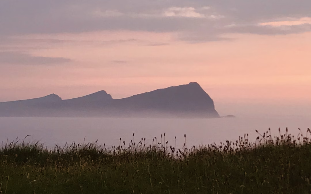
Wrapping up day 5 is the spectacular sunset view of The Three Sisters, known in Irish as “An Triúr Deirféar”. They are a trio of distinctive headlands that extend into the Atlantic Ocean, creating a dramatic coastal landscape. An Triúr Deirféar is steeped in Irish folklore, with various legends surrounding the formation of the three peaks.

Day 6: Ballydavid to Cloghane (11 miles)

Day 6 is tackling Mount Brandon, the highest peak on the Dingle Peninsula at 952 meters (3,123 feet). Named after Saint Brendan the Navigator, the mountain offers hikers panoramic views of the surrounding landscapes, including the Atlantic Ocean, the Blasket Islands, and the rugged terrain of County Kerry.


Day 7: Cloghane to Castlegregory (7.5 miles)

On the last day, we primarily walked on a long stretch of seemingly endless golden sandy beaches extending from the Maharees westward through Castlegregory (the entire beach is nearly 20-kilometer long).

The final destination is Fahamore, known in Irish as An Fhaiche Mhór (“The Big Green”), a small village situated on the Maharees Peninsula. The pier at Fahamore serves as a base for the local fishing fleet, especially in the summer time. The catches of the day include European lobster, spiny lobster (crayfish), spider crab, and Atlantic salmon.

